Contributed by: Henan Provincial Key Laboratory of Hydrosphere and Watershed Water Security | Edited by: Liu Ye | Preliminary Review: Liang Lili | Final Review: Qi Meng | Date: June 22, 2024
Under the leadership of Professor Liu Junguo, President of North China University of Water Resources and Electric Power (NCWU), the research team at the Henan Provincial Key Laboratory of Hydrosphere and Watershed Water Security has made significant progress in remote sensing monitoring of water resources. They have published multiple high-quality papers in top international journals such asNature Geoscience,Nature Communications,Remote Sensing of Environment,Water Resources Research, andGeophysical Research Letters. Their work has provided important remote sensing monitoring methods and technical support for the assessment and management of water resources in China and even the world.
The Henan Provincial Key Laboratory of Hydrosphere and Watershed Water Security, headed by Professor Liu Junguo, was established by NCWU, together with Tsinghua University, Southern University of Science and Technology, and the Yellow River Institute of Hydraulic Research, Yellow River Conservancy Commission. The laboratory conducts scientific research in four main directions: fundamental theories of hydrosphere science, intelligent watershed sensing technology, flood and drought prevention, and watershed ecological restoration, providing theoretical and technical support to ensure watershed water safety.
Satellite Remote Sensing Monitoring Technology for Lakes
Professor Feng Lian et al. published research findings inNature GeoscienceandNature Communications. They proposed a method for extracting lake boundaries based on deep learning and historical flooding frequency of water bodies and constructed a global lake dataset, GLAKES, which, for the first time, clarified the spatiotemporal dynamic evolution trends of 3.4 million lakes with water areas ≥0.03 km² worldwide from 1984 to 2019 (Figure 1). The study identified human activities as the dominant factor influencing changes in global lake areas and revealed that although small lakes (less than 1 km²) only account for 15% of the global lake area, they dominate half of the global lake area changes and contribute to increased carbon emissions. The team developed a fully automatic remote sensing identification algorithm for algal blooms in global waterbodies (Figure 2) and established the first lake algal bloom database in the world based on 2.91 million satellite remote sensing images. This database presented the spatiotemporal evolution characteristics of algal blooms in 240,000 lakes worldwide and demonstrated that the cumulative algal bloom area accounts for 11.7% of the total global lake area. Since the 2010s, the frequency and area of global algal blooms have significantly increased due to rising fertilizer use and climate warming. Compared to similar datasets, the above datasets feature extensive coverage (60°S–80°N), high spatial resolution (approximately 30 meters), long temporal scale (36 years), strong spatiotemporal consistency (non-spliced), high overall accuracy (greater than 98.7%), and detailed depiction of small lakes (minimum area of 0.03 km²).
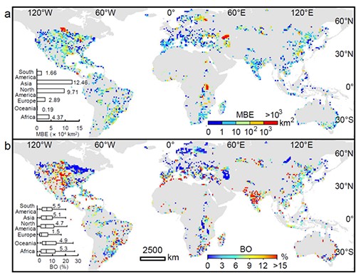
Figure 1. Temporal and spatial patterns of algal blooms in global lakes from 1982 to 2019
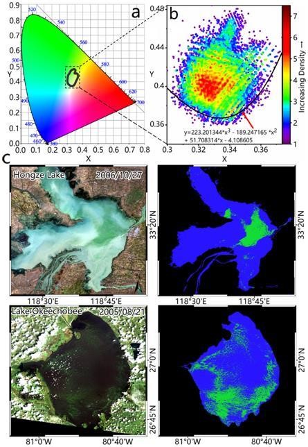
Figure 2. Algal bloom identification algorithm based on CIE color system. (a) CIE color space. (b) Density distribution of the selected algal bloom pixel green value in CIE xy chromaticity coordinates. (c) Algorithm extraction cases.
Remote Sensing Monitoring Technology for Droughts
Associate Professor Chen Kejie et al. published a research paper titled “A novel GNSS and precipitation-based integrated drought characterization framework incorporating both meteorological and hydrological indicators” inRemote Sensing of Environment. They first proposed an integrated drought characterization framework based on the Global Navigation Satellite System (GNSS) (Figure 3). The framework combines atmospheric water content and terrestrial water storage changes observed by GNSS with precipitation data to develop a comprehensive drought monitoring technology that incorporates both meteorological and hydrological indicators. GNSS stations are increasingly deployed worldwide. In addition to existing application scenarios such as positioning, navigation, timing, and crustal movement monitoring, GNSS can also provide technical support for integrated drought characterization and analysis in the context of global change. This innovative approach surpasses single-indicator systems, enabling a more comprehensive and accurate description of drought characteristics. It offers new ideas and technologies for global and regional drought monitoring based on geodesy.

Figure 3. Integrated drought characterization framework based on GNSS and precipitation data
Remote Sensing Analysis Technology for Global River Water Level Fluctuations
Assistant Professor Jiang Liguang et al. published a research paper titled “Tracking River’s Pulse From Space: A Global Analysis of River Stage Fluctuations” inWater Resources Research. In this study, the team used Sentinel-3 satellite altimetry data for the first time to develop remote sensing monitoring technology for river water levels. They constructed a water level time series dataset comprising 3,272 virtual stations on rivers globally, analyzed interannual variations in river water level fluctuations from 2016 to 2022, and discovered the potential relationships between spatial patterns of global river water level fluctuations and climate changes or human activities. The study showed that the Orinoco, Mississippi, Yangtze, Irrawaddy, and Amazon rivers have significant water level fluctuations, all exceeding 7 meters. The fluctuations at single stations vary from less than 1 meter to as much as 18 meters (Figure 4). This study was the first attempt to estimate water level fluctuations of large rivers worldwide using satellite altimetry data, illustrating the fluctuation amplitude and spatial patterns of global great rivers. Future research can extend to medium and small rivers, providing more detailed information for studying global river water level fluctuations.
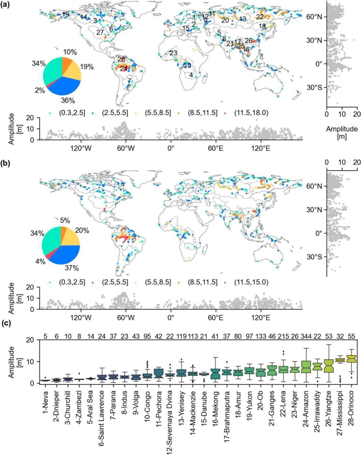
Figure 4. Distribution and statistical chart of long-term fluctuations of global river water levels
Research on the Drought Propagation Mechanism Based on the GNSS
Associate Professor Chen Kejie et al. published a research paper titled “Using the global navigation satellite system and precipitation data to establish the propagation characteristics of meteorological and hydrological drought in Yunnan, China” inGeophysical Research Letters. Based on data from 43 GNSS stations in Yunnan Province, the team explored the propagation mechanisms of meteorological and hydrological droughts. The study revealed that meteorological drought mainly occurs in spring and winter, primarily in northern Yunnan, with durations ranging from 1 to 11 months. In contrast, hydrological drought is more severe, with a wider impact range and durations from 2 to 16 months, indicating that meteorological drought is a major cause of hydrological drought (Figure 5). In this study, a new remote sensing monitoring method for drought propagation from meteorological to hydrological drought was established, providing technical support for mitigating drought disasters and issuing drought warnings.
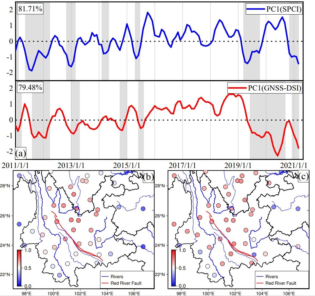
Figure 5. Temporal and spatial responses and potential correlations of meteorological and hydrological droughts in Yunnan Province
Dynamic River Network Extraction Technology Based on “Remote Sensing Stream Burning (RSSB)”
The team published a paper titled “Basin-scale high-resolution extraction of drainage networks using 10-m Sentinel-2 imagery” inRemote Sensing of Environment. Inspired by the “photolithography & etching” process in chip manufacturing, the team proposed the RSSB method. This method significantly improves the spatial and temporal accuracy of drainage networks constructed by etching the water mask onto the digital terrain model, providing a new technical means for the construction of large-scale high-resolution dynamic river networks (Figure 6). Compared to traditional methods, the RSSB method can reduce radial errors of river channels by approximately 50%.
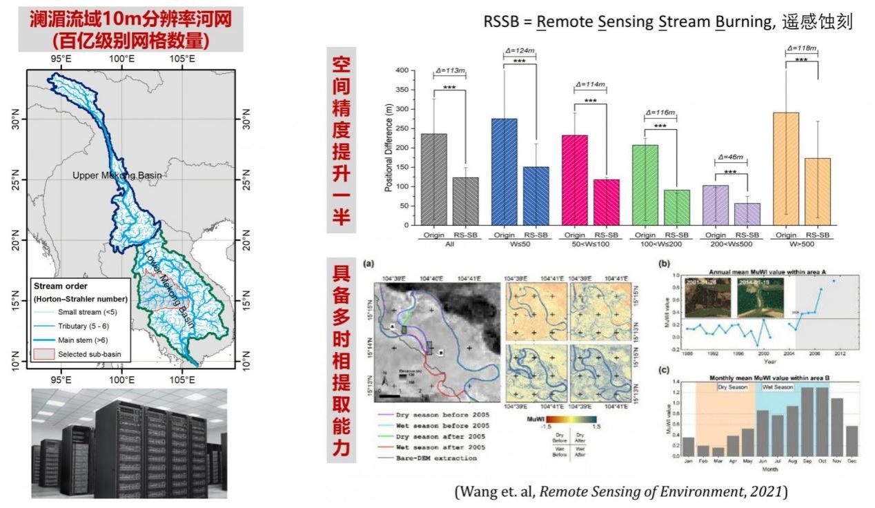
Figure 6. Remote sensing stream burning method
Streamflow Monitoring Technology Based on Sentinel Satellite Data
In collaboration with Professor Cheng Xiao’s team from Sun Yat-sen University, the team published a research paper titled “Estimating river discharge across scales with a novel regional gauging method driven by Sentinel satellite data” inRemote Sensing of Environment. The team invented a new regional monitoring method based on Sentinel satellite data for measuring periodic flood areas highly sensitive to changes in streamflow (streamflow-sensitive areas, SAs). Based on Sentinel-1 and Sentinel-2 data, this method achieves automatic extraction and water fraction estimation of SAs (Figure 7), thus enabling streamflow monitoring. The study showed that this method demonstrates high accuracy in monitoring streamflow across different widths and flow scales. The regional measurement method based on SAs is a promising technology, providing reliable data and methodological support for hydrology and water resource research and decision-making.
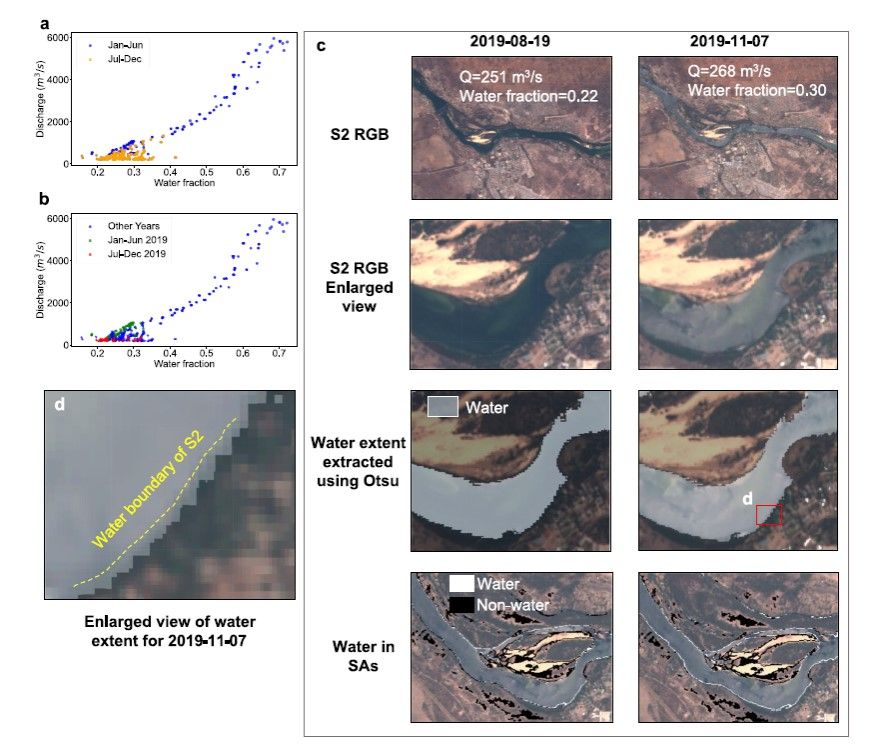
Figure 7. Water content distribution and data validation of the Zambezi River